
Our readers keep the lights on and my garage snacks stocked. As an Amazon Associate, I earn from qualifying purchases.
Specs are compiled from manufacturer listings and verified buyer reviews and can change over time — please confirm the key details on the product page before buying.
A standard car nav is useless once the pavement ends, and a phone screen dies fast when it is constantly hunting for a tower. That is where a real off-road GPS earns its keep: it runs on its own satellite network, survives dust and splashes, and shows you trails that never appear on Google Maps.
I’m Min Islam — the founder and writer behind Trending Car. This guide is built by comparing the manufacturers’ published specifications and the patterns across verified customer reviews, so you get each pick’s real strengths and trade-offs instead of marketing spin.
These four units are the best off-road GPS options for keeping your bearings when the road runs out. These four units are the best off-road GPS options for keeping your bearings when the road runs out.
Our Picks at a Glance


How To Choose The Best Off-Road GPS
Choosing an off-road GPS means focusing on what matters when you leave the pavement: keeping a satellite lock under thick trees, running for days on a single charge, and reading the screen in direct sunlight. Here is what to weigh before you click buy.
Satellite Support and Accuracy
A unit that only uses the standard GPS network can struggle in steep country or deep forests. Look for multi-band GNSS support — that means the device taps into multiple satellite constellations like GLONASS, Galileo, and QZSS at the same time. Multi-band technology, which the Garmin GPSMAP 65s uses, pulls signals from multiple frequencies to fight off interference from tree cover and canyon walls, giving you a tighter position lock.
Battery Life and Power Options
No cell tower means no charging cable from the truck. Handheld models like the eTrex 32x can run for up to 25 hours on a pair of AA batteries, which you can swap anywhere. Larger touchscreen units like the Montana 710 use a rechargeable lithium-ion pack that lasts up to 24 hours in GPS mode. If you are mounting the device to a vehicle, you can usually hardwire it to the battery, so runtime becomes a non-issue.
Maps and Trail Data
Preloaded TopoActive maps with routable roads and trails are the baseline for any serious off-road GPS. Some models add U.S. Forest Service Motor Vehicle Use Maps, public land boundaries, and even downloadable satellite imagery. If you ride snowmobile trails or explore private-land borders, check that the device includes those specific layers. Subscription services like Outdoor Maps+ can add slope angle and avalanche risk data, but you want the base maps to be solid from the start.
Screen Size and Durability
A glove-friendly touchscreen matters when you are wearing riding gear in cold weather. Handheld units use button controls that work with any glove. Vehicle-mounted navigators like the Tread 2 pack a 6- or 8-inch ultrabright display that stays readable in direct sunlight. Look for an IPX7 or IP67 rating — that means the device can handle rain, mud, and a dunking without giving up.
Form Factor and Mounting
Are you carrying the unit in your pocket or bolting it to the handlebars? Handheld models like the eTrex 32x are small enough to fit in a shirt pocket. Vehicle-specific units like the Tread series come with tube mount kits and wiring harnesses for a permanent install. If you switch between hiking and riding, a hybrid like the Montana 710 that works both in-hand and on a mount is the smart middle ground.
Quick Comparison
| Model | Best For | Satellite Support | Battery Life | Screen Size | Amazon |
|---|---|---|---|---|---|
| Garmin GPSMAP 65s★ Best Overall | Backcountry hikers demanding accuracy | Multi-band GNSS (GPS, GLONASS, Galileo, QZSS) | 10–27 hours | 2.6 inches | Amazon |
| Garmin eTrex 32xBest Value | Budget-conscious hikers and backpackers | GPS and GLONASS | 25 hours | 2.2 inches (240 x 320) | Amazon |
| Garmin Montana 710Premium Pick | Versatile handheld and vehicle use | GPS (with multi-GNSS support) | 24 hours / 432 hours expedition | 5 inches | Amazon |
In‑Depth Reviews
1. Garmin GPSMAP 65s
Our pick — 4.5★ from 300+ verified ratings; the strongest balance of quality and price.
The handheld that refuses to lose its lock under heavy tree cover
This is the unit you grab when the trail disappears into a dense forest or a steep canyon where a phone would be useless. The GPSMAP 65s uses multi-band GNSS technology, meaning it pulls signals from GPS, GLONASS, Galileo, and QZSS across multiple frequencies to fight off interference. Buyers report accuracy around 6 feet, and the lock is fast even indoors — so you are not standing around waiting for a fix while the sun drops. The large 2.6-inch sunlight-readable color display makes the map easy to read without cranking the backlight.
Battery life depends on how you run it. On Battery Save mode with GPS only, the unit stretches to about 27 hours. Crank the backlight to 100% and use multi-GNSS, and that drops closer to 10 hours. The good news is it runs on standard AA batteries, so you can carry spares and never be stuck. It also includes a 3-axis compass and barometric altimeter — ABC sensors that show you elevation and direction without needing to move.
The interface is a clear trade-off. Owners praise the functionality and accuracy — those are the most-discussed strengths — but the button-scrolling menu system feels dated. As the review pages sum it up: “the button scrolling to get to the menu item you need is tedious.” You trade modern touch convenience for rugged dependability and physical buttons that work with thick gloves. That is a fair swap if your priority is staying found, not swiping a screen.
Where It Wins
- Multi-band GNSS locks on fast in deep cover and steep terrain
- Replaceable AA batteries let you carry spares for multi-day trips
- Includes routable TopoActive maps and public land boundaries (U.S. only)
The Honest Trade-off
- Button-operated interface feels tedious after using a smartphone
- MicroSD card retention is weak — owners recommend tape to keep it seated
Reach for this if: you hike, hunt, or work in terrain where phone signals die and you need the most accurate satellite lock possible.
Look elsewhere if: you want a modern touchscreen interface and rarely venture beyond open trails.
2. Garmin eTrex 32x
The shirt-pocket navigator that runs for days on a pair of AAs
If you want a dedicated GPS that barely takes up pack space, the eTrex 32x is the crowd favorite for good reason. It measures just 2.1 by 1.3 by 4 inches — small enough to slide into a shirt pocket. The 2.2-inch sunlight-readable color display is modest but perfectly usable for trail navigation. Preloaded TopoActive maps with routable roads and trails mean you can start navigating dirt paths and hiking routes right from the start.
Battery life is the standout here. Garmin rates it at 25 hours in GPS mode, but owners mention a much wider range: from 13 hours with full backlight to 25 hours in Battery Save mode with WAAS off. , making it the better choice for a week-long trip where you cannot guarantee a battery swap. It supports GPS and GLONASS satellite systems, which keeps the track reliable in more challenging environments than a single-constellation unit.
The small size comes with a real caveat: the interface uses a control stick that takes time to learn, and the screen is tiny for detailed map work. Owners who use it for geocaching or intricate route planning sometimes find the zoom and redraw speeds frustrating. The trade-off is clear — you get a tough, long-lasting, lightweight GPS that fits anywhere, but you trade screen real estate and interface polish for that portability.
Strong Points
- Amazing battery flexibility — from 13+ hours to 25 hours depending on settings
- Extremely compact; fits in a shirt pocket without bulk
- Includes 3-axis compass and barometric altimeter for elevation and direction
Trade-offs
- Small 2.2-inch screen makes detailed map study difficult
- Control stick interface feels different and takes practice to master
Best for: hikers and backpackers who measure trips in days and want maximum battery life in the smallest possible package.
skip it if: you need a large, detailed map display for vehicle mounting or complex route planning.
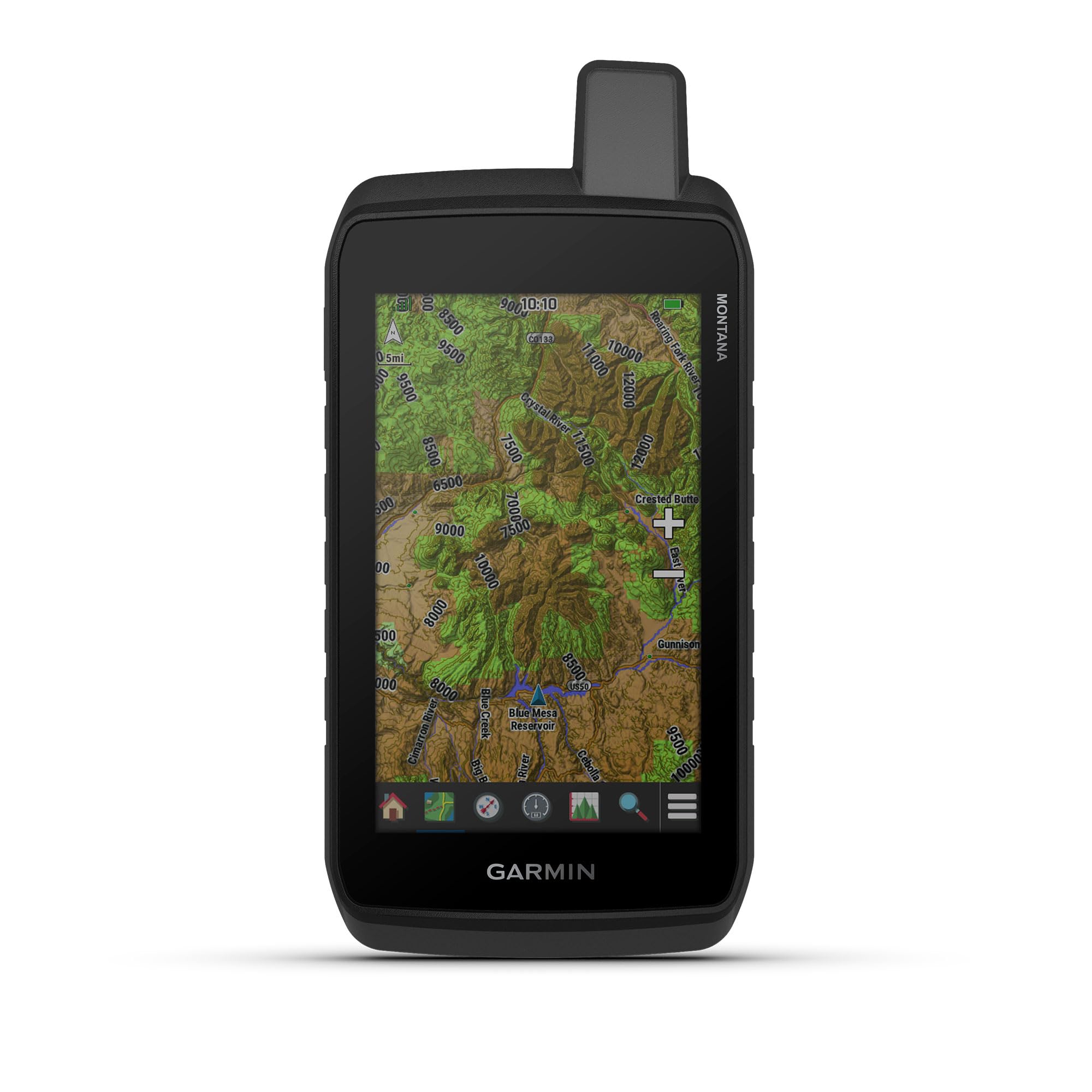
3. Garmin Montana 710
A 5-inch glove-friendly touchscreen that works in-hand or on the dash
The Montana 710 bridges the gap between a handheld and a vehicle-mounted navigator better than anything else here. Its 5-inch glove-friendly touchscreen is large enough to read at a glance on a motorcycle or ATV mount but still compact enough to carry when you step off the machine. The rugged construction meets MIL-STD 810 for thermal, shock, and vibration, plus an IPX7 water-resistance rating, so it survives rain, dust, and the occasional drop.
Battery life is a strong point. The rechargeable lithium-ion pack delivers up to 24 hours in GPS mode, and if you switch to expedition mode that stretches to an extreme 432 hours — useful for multi-day treks where you check position sparingly. You can also power it with traditional AA batteries if the lithium pack runs out. The built-in ABC sensors (altimeter, barometer, 3-axis compass) give you elevation data, weather trend info, and direction without relying on movement.
The crowd consensus is that versatility wins people over — owners use it on motorcycles, ATVs, and even boats. The biggest discussion point among buyers is reliability, which gets mixed feedback. Some customers note flawless long-term performance, while others flag occasional software quirks. The unit also supports downloadable high-resolution satellite imagery and 32 GB of internal memory for storing detailed maps, which is a big step up from the 8 GB on the eTrex 32x.
The Smart Compromise: You get a large, bright touchscreen with the option to swap in AA batteries on the trail, all in a body tough enough for vehicle mounting. The reliability questions mean this is a great fit if you want one GPS for both handheld and mounted use, but you may want a backup for critical solo trips.
Reach for this if: you switch between hiking and riding and want a single GPS that does both well.
Look elsewhere if: you need absolute rock-solid reliability from the start with zero software concerns.
4. Garmin Tread 2

Purpose-built for extreme weather with a 6-inch screen that stays bright in full sun
This is the navigator Garmin designed specifically for powersport vehicles — ATVs, UTVs, snowmobiles, and motorcycles. The Tread 2 packs a 6-inch high-resolution ultrabright touchscreen that remains readable in direct sunlight, and it carries an IP67 water and dust rating, meaning it is sealed against immersion and fine grit. The included rugged roll tube and handlebar mount options make installation straightforward on any machine.
The map content is where this unit separates from the handheld crowd. It includes turn-by-turn trail navigation for unpaved roads and trails with OpenStreetMap, U.S. Forest Service Motor Vehicle Use Maps, and Adventure Roads and Trails map content. Features like live group tracking and satellite imagery downloads do require a Wi-Fi or cellular connection, but the core navigation and positioning functions are fully independent.
What is the difference between GPS and GLONASS on these devices?
How do I update the maps on an off-road GPS?
Can I mount a handheld GPS on my motorcycle or ATV?
What does IPX7 or IP67 mean for a GPS unit?
How long do AA batteries last in an off-road GPS?
Can I load custom GPX routes from other apps onto these GPS units?
What is the difference between TopoActive maps and satellite imagery on these devices?
Will a motorcycle GPS work if I mount it on a snowmobile in freezing temperatures?
Final Thoughts: The Verdict
For most people, the best off-road GPS is the off-road gps Garmin GPSMAP 65s because it combines multi-band GNSS accuracy, long-lasting AA battery flexibility, and a rugged build that survives the backcountry. If you want a budget-friendly handheld with insane battery range, grab the Garmin eTrex 32x. For a large touchscreen that works both in-hand and on a vehicle mount, the Garmin Montana 710 is the one to reach for.
How We Picked
We do not accept paid placement. Every pick is matched to a real buyer and a real use-case; we do not hands-on test units.
Sources & Methodology
Specifications: manufacturer listings and product documentation. Review insights: verified customer reviews, as of July 2026. Pricing: not shown on this page (it changes often); check the current price via the retailer link.
As an Amazon Associate, Trending Car earns from qualifying purchases. This does not affect which products we feature.