
Our readers keep the lights on and my garage snacks stocked. As an Amazon Associate, I earn from qualifying purchases.
Specs are compiled from manufacturer listings and verified buyer reviews and can change over time — please confirm the key details on the product page before buying.
You are heading into a place where cell service dies, the trail markers vanish, and your phone’s map app is just a glowing paperweight. A handheld GPS navigator is not a nice-to-have out there — it is the one thing that turns “I think we went left” into a confident path home. The trick is picking the right one for the terrain you actually walk, paddle, or ride.
I’m Min Islam — the founder and writer behind Trending Car. This guide is built by comparing the manufacturers’ published specifications and the patterns across verified customer reviews, so you get each pick’s real strengths and trade-offs instead of marketing spin.
From a satellite communicator that works where no phone can to rugged trail companions with preloaded maps, these units cover every kind of outdoor mission. The goal of this guide is to help you find the best handheld gps navigator for exactly where you are headed.
Our Picks at a Glance


How To Choose The Best Handheld GPS Navigator
A handheld GPS navigator is not just a map in a box. It is your anchor in the backcountry, and the specs that matter most depend on how far you go and what you are doing when you get there. Focus on these three decisions first.
Battery Life: The Difference Between Reaching Trailhead and Not
Look at the battery average life in hours. A 20-hour unit covers a long day and maybe a second. A device that runs 168 hours on two AA batteries will get you through a full week of expedition travel without worrying about a power source. For true backcountry trips, units that let you swap in fresh AA batteries on the move are a real advantage — you carry spares instead of hunting for an outlet.
Satellite Reception: Why Multi-GNSS Matters
Older GPS units relied only on the American GPS satellite network. Modern Multi-GNSS support adds the Russian GLONASS, European Galileo, Chinese BeiDou, and Japanese QZSS constellations. More satellites overhead means the device can lock onto a signal faster and hold it in places where a single network struggles — deep canyon floors, heavy forest canopies, or narrow mountain valleys. If you spend time under trees or between cliffs, a Multi-GNSS handheld is a real step up.
Maps: Preloaded, Basemap, or No Map?
A “worldwide basemap” shows major roads, cities, and coastlines — enough to know which country you are in but not enough to follow a trail. A preloaded TopoActive map includes contour lines, trails, and water sources for real navigation. Some units ship with no maps at all; they record your track as a breadcrumb trail so you can retrace your steps. The right choice depends on whether you are bushwhacking, following marked trails, or navigating on open water.
Quick Comparison
| Model | Best For | Battery Life | Screen Size | Key Feature | Amazon |
|---|---|---|---|---|---|
| Garmin inReach Mini 3 Plus★ Best Overall | Satellite SOS & Messaging | 350 hours | 1.9″ Touchscreen | Global Iridium Network | Amazon |
| Garmin eTrex SEExpedition King | Extended Backcountry Trips | 168 hours | 2.2″ Display | Expedition Mode | Amazon |
| Garmin eTrex 10Best Value | Budget Reliability | 20 hours | 2.2″ Monochrome | Preloaded Basemap | Amazon |
| A6 Handheld GPS (NiesahYan) | Budget Track Logging | 20 hours | 2.4″ Color Screen | No Maps Included | Amazon |
In‑Depth Reviews
1. Garmin inReach Mini 3 Plus
Our pick — over 4.5★ from 90+ verified ratings; the strongest balance of quality and price.
The SOS button that works when your phone has zero bars and a dead battery.
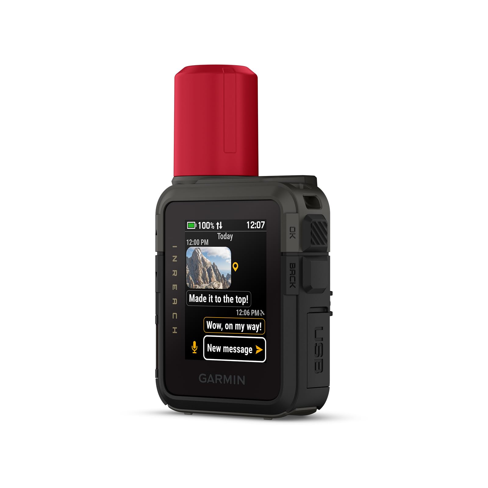
This is not just a GPS navigator — it is a full satellite communicator that hooks into the global Iridium network, the same constellation that covers the poles and the deep ocean. The 1.9-inch color touchscreen is scratch-resistant and rugged, carrying an IP67 water rating so a river crossing or a rainstorm will not stop it. Two-way text messaging hits 600 characters, and you can send photos and voice messages when paired with the Garmin Messenger app on your smartphone.
The battery average life hits 350 hours with 10-minute inReach tracking, while the A6 Handheld GPS offers 20 hours; the difference matters when you are out for a week or more. An interactive SOS message sends your location coordinates to the Garmin Response coordination center, a 24/7-staffed team that coordinates rescue. The device does not need to be aimed at the sky; it pulls satellite reception in wooded, dense, and remote locations. What wins people over is the build quality — owners praise the rugged construction and its suitability for emergencies. As the review pages sum it up: the device is “amazing.. helped me get out of the wilderness and track back to my car.” The downside is that the value for money is mixed in buyers’ minds — the satellite subscription is an ongoing cost that not everyone factors in. Think twice if you do not want a monthly plan; this device is for the person who treats communication in the backcountry as non-negotiable.
What Owners Celebrate
- Global Iridium satellite coverage works where no cell signal reaches.
- 350-hour battery life with 10-minute tracking is top-tier here.
- Interactive SOS sends your exact coordinates to a 24/7 response team.
The Ongoing Cost Reality
- Requires an active satellite subscription — an added monthly expense.
- Limited to SMS-style messaging; not a full internet device.
- Subscription is regulated or prohibited in some jurisdictions; check local law.
Reach for this if: your trips take you beyond cell range and you want two-way emergency messaging plus GPS tracking in a single rugged unit.
Look elsewhere if: you are not willing to pay a monthly subscription for satellite access or you only hike well-marked trails within cell coverage.
2. Garmin eTrex SE GPS Handheld Navigator
The week-long companion that runs on two AA batteries and never asks for a charge.
If your biggest worry is running out of power on day three, this is the handheld you want. The eTrex SE delivers up to 168 hours in standard mode and an incredible 1,800 hours in expedition mode using two field-replaceable AA batteries. That is not a typo — it runs for months in low-power mode, making it the endurance champion among the picks here. The 2.2-inch high-resolution display is sunlight-readable, and the Multi-GNSS support pulls in GPS, GLONASS, Galileo, BeiDou, and QZSS to hold a lock in challenging environments.
Bluetooth pairing with the Garmin Explore app brings wireless software updates, trip planning, and smart notifications from your phone. The digital compass gives you an accurate heading even when standing still. The IPX7 water-resistant design means a soaking rain or a drop in a stream is no problem. Owners say the battery lasts “3-5 weeks with 5 hrs/day” of use and that the screen is crisp and readable in direct sunlight. The main trade-off is the button-driven interface — the menu system has a learning curve, and some find the navigation “wonky” at first. If you prefer a color screen, note that this model is monochrome. The eTrex SE is for the multi-day backpacker who wants a lightweight, pocketable GPS they can depend on for weeks at a time.
Endurance Verdict: Nothing in this lineup matches its 1,800-hour expedition mode. If battery life is your primary spec, stop looking.
Ideal for: long-distance backpackers, geocachers on multi-week trips, and anyone who does not want to carry a power bank.
Not for: users who want a color touchscreen map display or a simple plug-and-charge experience.
3. Garmin eTrex 10 Worldwide Handheld GPS Navigator
The no-nonsense GPS that tens of thousands of owners trust for reliability over flashy features.
With a massive pool of ratings, the eTrex 10 is the most-proven handheld in this guide. It comes preloaded with a worldwide basemap so you can see major roads and coastlines from the start. The WAAS-enabled GPS receiver with HotFix and GLONASS support locks onto satellites fast and holds the signal in marginal conditions. The 2.2-inch monochrome display is not pretty, but it is incredibly readable in direct sunlight. Power comes from two AA batteries that deliver up to 20 hours of use, and the IPX7 waterproof rating means a dunk in a stream will not kill it.
The device supports paperless geocaching and stores waypoints along your track, showing high and low elevation points. Its reliability is the single most-praised aspect among a huge owner base, with owners describing it as the go-to unit for geocaching and hunting. The screen scratches easily, so a screen protector is a smart addition. The monochrome display and button-only interface feel dated, but that simplicity is exactly what many buyers want — a GPS that works every time you press the power button, with nothing to distract you from the trail.
Reliability Report: This unit has earned its reputation. Owners consistently call it durable, accurate, and long-lasting. The simplicity is the feature.
Grab this if: you want the most trusted, value-conscious GPS for geocaching, hunting, or hiking with zero learning curve for basic navigation.
Think twice if: a color map display or touchscreen interface is essential to your outdoor routine.
4. Garmin GPSMAP 79s Marine GPS Handheld

A 3.2-inch sunlight-readable screen with preloaded USA Topo maps at a mid-range price point.
This NiesahYan device sets itself apart from the budget A6 model with a larger screen and preloaded USA Topo maps. The 3.2-inch sunlight-readable display is the second-largest in the guide, and the anti-slip design combined with physical buttons makes it easy to handle in wet or cold conditions. Multi-GNSS support pulls in GPS, Galileo, BeiDou, and QZSS for positional accuracy within 6 feet. The 3-axis compass and barometric altimeter give you accurate heading and elevation data whether you are moving or stationary.
The rechargeable battery provides up to 36 hours of life on a full charge, and the IP66 water-resistant design handles rain and splashes. The 32 GB of internal memory gives you plenty of room for additional map downloads. Owners praise the screen size and accuracy, noting it “struggles to connect in the city but great in the open terrain of the mountains.” Some owner experiences flagged a device that failed to boot after the first field test, and the directions are described as not thorough enough for new users. This unit is a solid contender if you want preloaded topo maps without moving up to the premium price of the Montana 710, but set realistic expectations about the documentation quality.
Map Advantage: Preloaded USA Topo maps from the start set it apart from the A6 model, which has no maps at all. The 36-hour battery is also a step up.
Reach for this if: you want preloaded USA Topo maps and a large sunlight-readable screen at a price below the premium tier.
Think twice if: you want a flawless first-run experience or need detailed city navigation — signal is weaker in urban areas.
5. A6 Handheld GPS for Hiking (NiesahYan)

A compact color-screen GPS that tracks your route and guides you back — no map subscription needed.
The A6 is a lightweight, straightforward GPS handheld with a 2.4-inch high-resolution color screen that is bright enough to read in direct sunlight. The rechargeable battery provides up to 20 hours of continuous use and charges via a standard USB-C cable. It uses Multi-GNSS support to get a lock under tree cover, and owners confirm it gets a “fast GPS lock, bright screen, good under tree cover.” The device records your track before a hike and can guide you back to your starting position, storing waypoints along a route.
It comes with essential tools like a GPS compass for accurate heading, a barometric altimeter, and sunrise/sunset times. The IP66 water-resistant rating means it handles rain. The critical catch is that the A6 has no maps — it navigates by breadcrumb trail only. The instructions are limited, and a few owners reported issues with accuracy on steep, winding trails. For a budget-conscious hiker who simply needs to know they can retrace their steps, the A6 gets the job done without the price tag of a Garmin unit.
Budget Reality: It is a capable track logger with a bright color screen and reliable GPS lock. Just know you are not paying for maps or a polished user interface.
Ideal for: day hikers who want a simple breadcrumb-trail GPS to find their way back, without the cost of a top-tier Garmin.
Not for: anyone who wants preloaded maps, turn-by-turn navigation, or a device with thorough documentation and support.
Understanding the Specs
Battery Average Life (Hours)
This is the number that determines how long you can stay out without a power source. A 20-hour unit gets you through a long day and maybe two. A 168-hour unit (like the Garmin eTrex SE’s standard mode) can last a full week. Expedition modes stretch that even further by reducing the polling rate of the GPS receiver — the eTrex SE reaches 1,800 hours in expedition mode. Units that use standard AA batteries let you carry spares; built-in rechargeables require you to find a USB outlet.
Multi-GNSS Support
Older GPS units used only the US GPS network. Multi-GNSS devices add the Russian GLONASS, European Galileo, Chinese BeiDou, and Japanese QZSS constellations. More satellites overhead means the device locks onto a signal faster and holds it in places where a single network struggles — deep canyons, under heavy tree cover, or in narrow mountain valleys. If you hike in the woods or between cliffs, Multi-GNSS is the spec that keeps you on track.
Satellite SOS & Two-Way Text
A satellite SOS feature (found on the Garmin inReach Mini 3 Plus) sends your exact location coordinates to a 24/7-staffed coordination center that arranges rescue. Two-way text messaging lets you communicate with that center or with friends and family — all without a cell signal. This requires an active satellite subscription and works over the Iridium satellite network, which covers the entire planet including the poles and oceans.
Screen Type & Sunlight Readability
A monochrome display (like the Garmin eTrex 10) is extremely readable in direct sunlight and uses less power than a color screen. A color touchscreen (like the Garmin Montana 710’s 5-inch display) gives you a richer map view with satellite imagery but is harder to read in bright light without an anti-glare coating. Sunlight readability is the spec that tells you whether your screen will be usable on a bright day above the treeline.
FAQ
Can a handheld GPS work without cell service?
Do I need a subscription to use a handheld GPS?
What is the difference between a worldwide basemap and a TopoActive map?
Can a GPS device with no maps still navigate me back to my starting point?
How long do AA batteries last in a handheld GPS compared to a rechargeable battery?
Can I use a marine GPS like the GPSMAP 79s for hiking?
What is a GMRS license and do I need one for the Garmin Rino 700?
Can I download additional maps onto any handheld GPS?
How accurate is the GPS position on a handheld in the trees?
Can I share my location in real time with friends and family using a handheld GPS?
Final Thoughts: The Verdict
For most people, the best handheld GPS navigator is the Garmin inReach Mini 3 Plus because it bundles global satellite SOS, two-way texting, and GPS navigation into a rugged, 4.31-ounce package that works anywhere on Earth — the confidence it offers is class-leading by any other unit here. If you want week-long battery life and reliable tracking without a subscription, grab the Garmin eTrex SE. And for a big touchscreen with satellite imagery that doubles as a motorcycle or vehicle GPS, the Garmin Montana 710 is the one to reach for.
How We Picked
We do not accept paid placement. Every pick is matched to a real buyer and a real use-case; we do not hands-on test units.
Sources & Methodology
Specifications: manufacturer listings and product documentation. Review insights: verified customer reviews, as of July 2026. Pricing: not shown on this page (it changes often); check the current price via the retailer link.
As an Amazon Associate, Trending Car earns from qualifying purchases. This does not affect which products we feature.